
Methodology
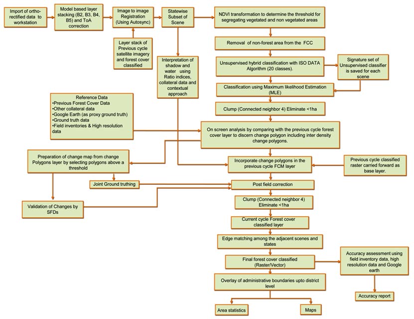
The Figure shows the schematic diagram of the methodology. Using Digital Image Processing (DIP) software, the satellite data in digital form was downloaded on the Workstations from the CDs procured from the NRSA. Top of the Atmospheric correction were applied for removing radiometric defects and for improving visual impact of the False Color Composites (FCC).
Ortho-rectified satellite data in UTM projections, with datum spheroid WGS84 is being adopted for FCM exerise from the current 16th cycle assessment onwards and this has better positional accuracy compared to the previous cycle satellite data rectified using survey of india toposheets.
Schematic diagram showing Methodology of Forest Cover Mapping
The methodology of interpretation involves a hybrid approach in which unsupervised classification (ISODATA algorithm) aided on-screen visual interpretation of forest cover was done.
Normalized Difference Vegetation Index (NDVI) transformation was used for removing non-vegetated areas from the scene. Areas of less than one hectare, whether classified as forest cover within non-forest areas or blanks within forest cover, were excluded by appropriate DIP techniques. The approach relies a lot on the skill of the analysts. The analyats. The analysts have good understanding about the topography, forests and land use related aspects of the area. This human input is an essential component of the forest cover mapping exercise.
Degraded forests with tree canopy density less than 10 percent have been classified as scrubs, which do not form part of the forest cover.
Shadow areas in the scenes have been treated separately. Shadow regions on the images are highlighted using band ratio techniques. Forest cover classification of the totally obscure areas due to shadow or cloud cover has been done using the ground truth information.
Mangrove forests have characteristic tone and texture on the satellite image. Their presence on the coastal areas makes them even more conspicuous. They have been, therefore, separately classified.
This was then followed by extensive ground verification which takes more than six months. All the necessary corrections were subsequently incorporated. Reference data collected through ground truth and field experience of the interpreter played an important role in delineating the forest cover patches and classifying them into three canopy density classes.