Screen Reader Access | Skip to Main Content | Skip to Navigation |
  • qoo
  • |
  • Hindi
FSI

Contact Us

dgfsi [at] fsi [dot] nic [dot] in

logo

  • Home
  • About Us +
    • Brief History
    • Objectives
    • Major Activities
    • Organization Setup
    • Who is who
    • Publications
    • Telephone Directory
    • Annual Report
    • Photo Gallery
    • Video Gallery
  • Zonal Offices +
    • Introduction
    • Northern Zone Shimla
    • Eastern Zone Kolkatta
    • Central Zone Nagpur
    • Southern Zone Banglore
  • Forest Cover Mapping +
    • Introduction
    • Methodology
    • Scale of Interpretation
    • Scheme of Classification
    • Limitations
  • Forest Fire +
    • Forest Fire activities
    • Focus Areas
    • How to Register for Forest Fire
    • Go to FSI Forest Fire Portal
    • Large Fire Monitoring Programme
    • Reports Publication
    • Brief Description of Forest Fire Activities in FSI
  • Forest Inventory +
    • About Forest Inventory
  • Reports +
    • Inventory Reports
    • Carbon Reports
    • Zonal Reports
    • Vulnerability of Forest Fire
    • Technical Information Series
    • NATCOM REPORTS
  • State of Forest Report +
    • Year 2023
    • Year 2021
    • Year 2019
    • Year 2017
    • Year 2015
    • Year 2013
    • Year 2011
    • Year 2009
    • Year 2005
    • Year 2003
    • Year 2001
    • Year 1999
    • Year 1997
    • Year 1995
    • Year 1993
  • Training
  • DSS +
    • MoEF FSI Decision Support System Geoportal
    • E-Green Watch
    • FSI Node
  • Projects +
    • Ongoing Projects
    • Completed Projects
  • Home
  • About Us
    • Brief History
    • Objectives
    • Major Activities
    • Organization Setup
    • Who is who
    • Publications
    • Telephone Directory
    • Annual Report (pdf, 1.21 MB)
    • Photo Gallery
    • Video Gallery
  • Zonal Offices
    • Introduction
    • Northern Zone Shimla
    • Eastern Zone Kolkatta
    • Central Zone Nagpur
    • Southern Zone Banglore
  • Forest Cover Mapping
    • Introduction
    • Methodology
    • Scale of Interpretation
    • Scheme of Classification
    • Limitations
  • Forest Fire
    • Forest Fire activities
    • Focus Areas
    • How to Register for Forest Fire
    • Go to FSI Forest Fire Portal
    • Large Fire Monitoring Programme
    • Reports Publication
    • Brief Description of Forest Fire Activities in FSI
  • Forest Inventory
    • About Forest Inventory
  • Reports
    • Inventory Reports
    • Carbon Reports
    • Zonal Reports
    • Vulnerability of Forest Fire
    • Technical Information Series
    • NATCOM REPORTS
  • State of Forest Report
    • Year 2023
    • Year 2021
    • Year 2019
    • Year 2017
    • Year 2015
    • Year 2013
    • Year 2011
    • Year 2009
    • Year 2005
    • Year 2003
    • Year 2001
    • Year 1999
    • Year 1997
    • Year 1995
    • Year 1993
  • Training
  • DSS
    • MoEF FSI Decision Support System Geoportal
    • E-Green Watch
    • FSI Node
  • Projects
    • Ongoing Projects
    • Completed Projects


Important Links
Tenders Vacancies Training Calendar 2022-23 Procurement Of Maps Center Public Information Officer NWPC-23 Meri Yojna Book

Forest Cover Mapping

  • Introduction
  • Methodology
  • Scale of Interpretation
  • Scheme of Classification
  • Limitations

Scale of Interpretation

The first assessment in 1987 was done visually on 1:1 million scale. Thereafter, upto 1999 the assessment was done on 1:250,000 scale. On this scale, the country was covered by 363 toposheets of SOI. To enrich the information on forest cover and to make it more useful, assessment on 1:50,000 scale is desirable and has been taken up since the 2001 assessment for the forest cover assessment to be done on 1:50,000 scale, the quantum of work increase manifold as the country is covered by 5,200 sheets on this scale. However, the application of DIP reduces the time taken in interpretation significantly.

DIP technique offers a more objective assessment of forest cover at a larger scale and better cartographic presentation, thus overcoming the limitations of visual interpretation to a large extent. Advantages of the forest cover mapping on larger scale would be evident from Fig. which shows that the details, not discernable on 1:250,000 scale, are highlighted on 1:50,000 scale. In case of fragmented forest, the area of forest cover decreases as the openings which were not clearly discernible on the smaller scale are picked up on the larger scale. Conversely, the scattered small patches of forests/plantations, not discernible at smaller scale, are included in the assessment on larger scale thus adding to forest cover.

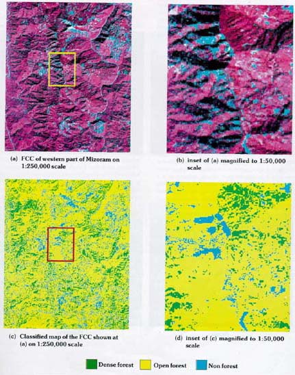
Fig. Illustration of Magnification of Details with the Enhancement of Scale

STATE OF FOREST REPORT 2023

India State of Forest Report (ISFR) is a biennial publication of Forest Survey of India (FSI) an organization under the Ministry of Environment Forest & Climate Change Government of India

Download Now

Important Links

  • Home
  • Special Studies
  • Useful Links
  • Events
  • RTI


  • Terms & Conditions
  • Reading Material
  • Training
  • Enquiries
  • Accessibility

Get in Touch

  • Forest Survey of India Ministry of Environment Forest and Climate Change Kaulagarh Road P.O. IPE Dehradun -248195 Uttarakhand India

  • 0135275613927545072755037

  • dgfsi [at] fsi [dot] nic [dot] in, jdtfi [at] fsi [dot] nic [dot] in, jdnfdmc [at] fsi [dot] nic [dot] in

  • qoo

Developed by: Digital Prefix Media

Copyright 2023 All Right Reserved : Forest Survey of India