Screen Reader Access | Skip to Main Content | Skip to Navigation | Hindi
  • qoo
FSI

Contact Us

dgfsi [at] fsi [dot] nic [dot] in

logo

  • Home
  • About Us +
    • Brief History
    • Objectives
    • Major Activities
    • Organization Setup
    • Who is who
    • Publications
    • Telephone Directory
    • Annual Report
    • Photo Gallery
    • Video Gallery
  • Zonal Offices +
    • Introduction
    • Northern Zone Shimla
    • Eastern Zone Kolkatta
    • Central Zone Nagpur
    • Southern Zone Banglore
  • Forest Cover Mapping +
    • Introduction
    • Methodology
    • Scale of Interpretation
    • Scheme of Classification
    • Limitations
  • Forest Fire +
    • Forest Fire activities
    • Focus Areas
    • How to Register for Forest Fire
    • Go to FSI Forest Fire Portal
    • Large Fire Monitoring Programme
    • Reports Publication
    • Brief Description of Forest Fire Activities in FSI
  • Forest Inventory +
    • About Forest Inventory
  • Reports +
    • Inventory Reports
    • Carbon Reports
    • Zonal Reports
    • Vulnerability of Forest Fire
    • Technical Information Series
    • NATCOM REPORTS
  • State of Forest Report +
    • Year 2023
    • Year 2021
    • Year 2019
    • Year 2017
    • Year 2015
    • Year 2013
    • Year 2011
    • Year 2009
    • Year 2005
    • Year 2003
    • Year 2001
    • Year 1999
    • Year 1997
    • Year 1995
    • Year 1993
  • Training
  • DSS +
    • MoEF FSI Decision Support System Geoportal
    • E-Green Watch
    • FSI Node
  • Projects +
    • Ongoing Projects
    • Completed Projects
  • Home
  • About Us
    • Brief History
    • Objectives
    • Major Activities
    • Organization Setup
    • Who is who
    • Publications
    • Telephone Directory
    • Annual Report (pdf, 1.21 MB)
    • Photo Gallery
    • Video Gallery
  • Zonal Offices
    • Introduction
    • Northern Zone Shimla
    • Eastern Zone Kolkatta
    • Central Zone Nagpur
    • Southern Zone Banglore
  • Forest Cover Mapping
    • Introduction
    • Methodology
    • Scale of Interpretation
    • Scheme of Classification
    • Limitations
  • Forest Fire
    • Forest Fire activities
    • Focus Areas
    • How to Register for Forest Fire
    • Go to FSI Forest Fire Portal
    • Large Fire Monitoring Programme
    • Reports Publication
    • Brief Description of Forest Fire Activities in FSI
  • Forest Inventory
    • About Forest Inventory
  • Reports
    • Inventory Reports
    • Carbon Reports
    • Zonal Reports
    • Vulnerability of Forest Fire
    • Technical Information Series
    • NATCOM REPORTS
  • State of Forest Report
    • Year 2023
    • Year 2021
    • Year 2019
    • Year 2017
    • Year 2015
    • Year 2013
    • Year 2011
    • Year 2009
    • Year 2005
    • Year 2003
    • Year 2001
    • Year 1999
    • Year 1997
    • Year 1995
    • Year 1993
  • Training
  • DSS
    • MoEF FSI Decision Support System Geoportal
    • E-Green Watch
    • FSI Node
  • Projects
    • Ongoing Projects
    • Completed Projects


Important Links
Tenders Vacancies Training Calendar 2022-23 Procurement Of Maps Center Public Information Officer NWPC-23 Meri Yojna Book

Forest Cover Mapping

  • Introduction
  • Methodology
  • Scale of Interpretation
  • Scheme of Classification
  • Limitations

Scheme of Classification

The forest cover is broadly classified in 4 classes, namely very dense forest, moderately dense forest, open forest and mangrove. The classification of the cover into dense and open forests is based on internationally adopted norms of classification. It has not been possible to further segregate the dense forest into more classes owing to enormity of work of ground validation and limitations of methodology. Mangroves have been separately classified because of their characteristic tone and texture and unique ecological functions. The other classes include scrub and non-forest. These classes are defined is below.

Classification Scheme

Very dense Forest All Lands with tree cover (Including mangrove cover) of canopy density of 70% and above
Mod Dense forest All lands with tree cover (Including mangrove cover) of canopy density between 40% and 70% above
Open forest All lands with tree cover (Including mangrove cover) of canopy density between 10% and 40%
Scurb All forest lands with poor tree growth mainly of small or stunted trees having canopy density less than 10 percent
Non Forest Any area not included in the above classes

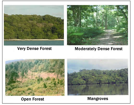
Fig. Pictorial Illustration of Different Classes of Forest

STATE OF FOREST REPORT 2023

India State of Forest Report (ISFR) is a biennial publication of Forest Survey of India (FSI) an organization under the Ministry of Environment Forest & Climate Change Government of India

Download Now

Important Links

  • Home
  • Special Studies
  • Useful Links
  • Events
  • RTI


  • Terms & Conditions
  • Reading Material
  • Training
  • Enquiries
  • Accessibility

Get in Touch

  • Forest Survey of India Ministry of Environment Forest and Climate Change Kaulagarh Road P.O. IPE Dehradun -248195 Uttarakhand India

  • 0135275613927545072755037

  • dgfsi [at] fsi [dot] nic [dot] in, jdtfi [at] fsi [dot] nic [dot] in, jdnfdmc [at] fsi [dot] nic [dot] in

  • qoo

Developed by: Digital Prefix Media

Copyright 2023 All Right Reserved : Forest Survey of India